One of the most spectacular drives in Cuba

 The southeastern corner of Cuba often remains unexplored by travelers, but a lesser-known route offers a captivating glimpse into the nation's revolutionary past.
When I informed the car rental manager in Bayamo, Cuba, that we intended to take the alternative route to Santiago, he cautioned us about the remote nature of the road. He emphasized that the lack of cell signal meant that if our car broke down, help might take a significant amount of time to arrive.
This back road, known as the Carretera Granma or the southern coastal road, follows the perimeter of Granma province in eastern Cuba. It's so secluded that even Fidel Castro, who initiated his grassroots revolution against President Fulgencio Batista here in 1956, visited the area only once in his lifetime. The province derives its name from the 18-meter motor yacht, Granma, which Castro and his fellow revolutionaries sailed from Mexico to Cuba, crashing ashore near this very road and subsequently navigating through dense mangroves to launch their movement.
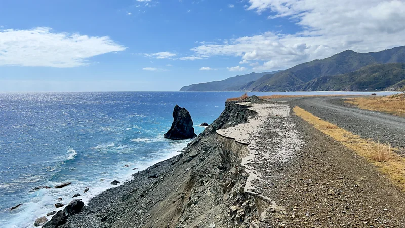
Although the central highway may seem like the logical route between Bayamo and Santiago de Cuba, this remote and occasionally rugged road, weaving between the turquoise ocean and the towering Sierra Maestra mountains along Cuba's southern border, offers breathtaking vistas that often leave drivers and passengers spellbound. Having traveled to Cuba for 25 years, I consider it the most stunning road trip in the country, offering glimpses of Cuba's revolutionary history alongside awe-inspiring scenery.
Exploring Granma's Historic Road: From Bayamo to Santiago de Cuba
 Covering a total distance of 420km, my journey would lead me from Bayamo westward to the coast, then tracing Granma province's triangular shape counterclockwise to Santiago de Cuba. Despite having driven this road solo in the past, concerns about Cuba's ongoing fuel shortages prompted me to hire a second driver, Rafa González, through Bayamo Travel Agent. While a full tank could theoretically take us to Santiago, I opted for added security given the remote nature of the road and the limited mobile phone signal.
Away from the imposing Sierra Maestra, Granma reveals itself as a province of rolling fields, swaying sugar cane, expansive skies, and fluffy clouds. It proudly commemorates the region's rebellious history. As González and I navigated through the potholed roads out of Bayamo, we passed by painted portraits of key figures from Cuba's 1959 Revolution adorning large roadside stone slabs, evoking the sensation of traveling through the pages of a Cuban history book.
Beyond the revolutionary era, this road also unveils traces of Cuban history dating back long before the revolution. In the quaint town of Yara, located 44km west of Bayamo, we encountered the story of Hatuey, an indigenous Taíno leader who was executed by the Spanish in 1512 for refusing to convert to Christianity. His ashes are said to have spiraled into the sky, inspiring the legend of Luz de Yara, a mysterious light occasionally observed illuminating these distant fields—a tale ingrained in the upbringing of most Cubans.
Continuing our journey, we paused in the tranquil coastal town of Manzanillo to indulge in one of Cuba's delectable treats—a triangular pastelito de guayaba (guava pastry). Heading southwest along the ridge of Granma's "foot," we encountered a landscape adorned with banana plantations, coconut palms, and a variety of fruit trees lining the roadside, framed by swaying sugar cane fields.
Exploring Historical Landmarks along Cuba's Southern Coastal Road
 Our journey brought us to the ruins of La Demajagua sugar plantation, a site steeped in significance as the birthplace of Cuba's first wars of independence against Spain. Here, in 1868, Carlos Manuel de Céspedes liberated his 53 slaves, marking a pivotal moment in Cuban history. Today, the site exudes tranquility, with butterflies fluttering over jasmine flowers, a serene atmosphere enveloping the few remaining ruins, and a venerable jagüey tree providing shade. A small museum and a bell, once a symbol of freedom, add to the site's peaceful ambiance.
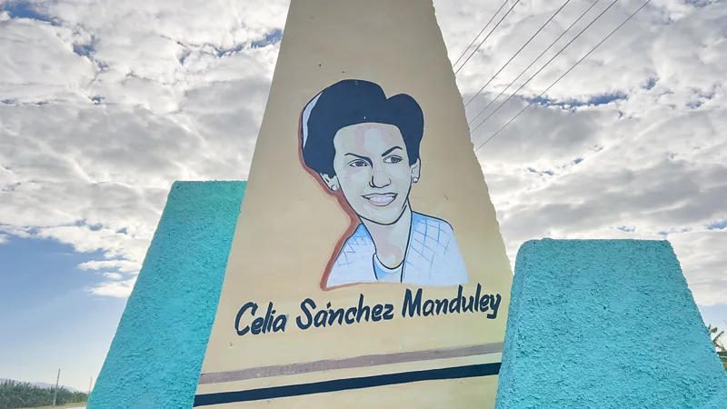
Continuing our drive, we stopped at the birthplace-turned-museum of Cuban revolutionary Celia Sánchez in the town of Media Luna, located 40 kilometers south. As the daughter of a doctor, Sánchez played a crucial role in Castro's rebel movement, serving as a spy and aiding the escape of Castro and his men after their ship, the Granma, was wrecked offshore. She later became Castro's secretary, confidante, and, according to some accounts, his lover.
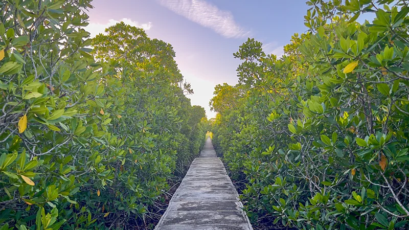
Further along the rough road, we arrived at Cabo Cruz, the southernmost cul-de-sac of mainland Cuba. Here, a solitary lighthouse stands sentinel over a fishing community of 500 homes, while nearby lies a series of eight UNESCO-protected marine terraces, resembling giant stepping stones. This area also encompasses the Granma Landing National Park, a forested expanse dotted with karstic caves and serving as the landing site for Castro and his men in 1956.
The following morning, guided by Leonel Fontaines Alvarez, we ventured 1,500 meters out to sea on a concrete platform to reach the spot where the revolutionaries made landfall. A modest stone and plaque mark this historic event—a humble monument commemorating a monumental chapter in Cuban history.
The Arduous Journey of Fidel Castro and his Rebels through the Cuban Wilderness
 As we gazed at the thick greenery, the speaker noted the immense challenge faced by Fidel Castro and his companions as they navigated the mangroves for five grueling hours. Laden with heavy backpacks and rifles, lacking machetes, and disoriented, they endured hardship.
Subsequently, seeking refuge in the Sierra Maestra mountains for two years, they endured scarcity, disease, and relentless attacks from Batista's forces. Yadi León Quintero, wife of Alvarez and a guide, described the extreme conditions the rebels faced in the Sierra Maestra, highlighting their hunger, thirst, limited weaponry, and constant pursuit by the enemy.
From their mountain hideouts, they launched assaults on garrisons and rallied supporters. The Sierra Maestra's rugged terrain provided unparalleled concealment, crucial to the rebels' success.
Today, the once-battle-scarred coast teems with wildlife, offering a stark contrast to its tumultuous past. The journey continued to La Comandancia de la Plata, Castro's covert headquarters turned museum, nestled deep within the mountains. Accessible only by a lengthy trek from Alto de Naranjo, this rustic outpost offers insight into the rebels' secluded existence.
Retracing Fidel Castro's Historic Route to Santiago
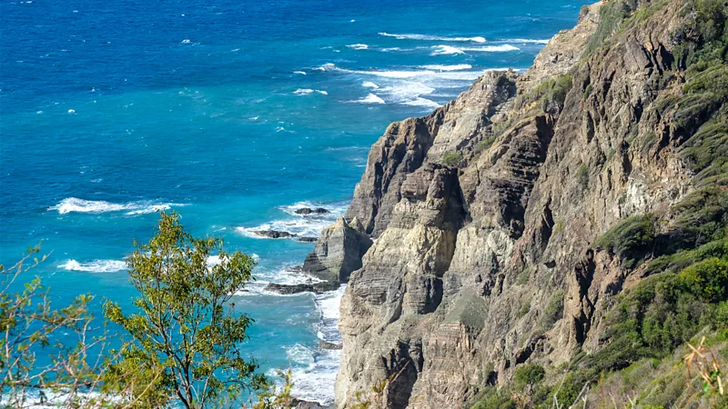 Continuing past Pilón, the road skirted towering rock formations, gradually deteriorating as it wound alongside seagrape trees and the coastline. Ascending, we were treated to panoramic vistas of verdant peaks and the restless sea, catching glimpses of Pico Turquino amidst fleeting clouds. The abrupt rise of the mountains made it challenging to focus on the road, punctuated by encounters with local cowboys on horseback. In La Plata, we visited the
Museo Combate de la Plata, commemorating Castro's inaugural victory in January 1957, which affirmed the Rebel Army's readiness to combat Batista's regime. Beyond La Plata, the road snaked along stunning coastal scenery, passing through Uvero, site of the rebels' pivotal ambush in 1957. The landscape transitioned from indigo waters and black sand coves to villages nestled amid black and white sands on the route to Santiago. Remarkably, a scenic road now allows modern travelers to retrace much of Castro's arduous journey to Santiago, where he delivered his triumphant address in 1959, marking the end of Batista's regime.